2015-09-29 Hampton–Campbell Creek

Our visit to Hampton allowed us to attend a Memorial Service to honor Annette’s Uncle Don. I have enjoyed our visits to Hampton largely because of our visits with Don and Ester. Don was always so enthusiastically supportive of Annette in our choice to take off on a boat! His support of our choice was much appreciative. It was a lovely service and nice to spend quality time with many of Annette’s relatives.  

2015_09_16_21_25_46_AWB-005

We moor at Sunset Boating Center in Hampton VA with is really a rack and stack marina but they do have a couple transient docks. The location up Sunset Creek is quiet and convenient.

2015_09_14_21_01_02_AWB-021

I almost forgot! We got our first Uber Car ride while we were in Hampton!

2015_09_16_19_48_39_AWB-004

Our next stop was just 13 miles up the Elizabeth River at Portsmouth to visit with my niece Lori and Adam. We enjoyed a lovely evening catching up.

Capture -1

As we prepared for departure we waited for a little fog to burn off. We wanted to get moving because of some forecast winds coming in later in the morning.

2015_09_20_08_48_12_AWB-007

Rather than burning off the fog just continued to get heavier and heavier.

2015_09_20_09_08_57_AWB-008

Gratefully we were able to get moving and settled at Hospital Point right in front of the Portsmouth Naval Hospital.

2015_09_20_14_53_06_AWB-010

Our friend Ed Darling was also out on their boat and got a nice picture of there boat in front the Norfolk waterfront.

2015_09_20_14_42_10_AWB-022

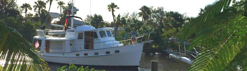
Ed passed close by and got a couple of nice pictures of Magnolia at anchor….thanks Ed!!!

2015_09_20_16_42_14_AWB-017

2015_09_20_16_42_22_AWB-016

After our overnight stop in Portsmouth it was time to start the 144 mile trip down to our friends in Campbell Creek NC.

Capture -2

The first goal though was to clear the hectic Norfolk waterways. The Gilmerton Bridge is the one restricted bridge that we needed to wait for an opening. You can see the track below where Annette and to make a couple of loops waiting for the the bridge.Capture -3

There are two water routes which would allow us to travel south. The more commercial route is called the Virginia Cut but we prefer the more picturesque Dismal Swamp route. Just a mile or so beyond the Gilmerton Bridge is the turn on off for the Dismal Swamp.

Capture -4

Our next small obstacle to progress is the Deep Creek. The Gilmerton opens at 08:30 but the locks mid-morning locking is at 10:30 and since there is so little other traffic we just drop the anchor right in front of the lock!

Capture -5

We had 4 other boats join us in the lock this trip. The Dismal Canal is actually 8 feet aboave sea level. The one end of the canal you are raised 8 feet and the other you are lowered 8 feet. Keep in mind canal was dug by hand I think in the early 1800s!

2015_09_21_13_18_54_AWB-013

As you can see, one you get through Deep Creek Lock it’s a pretty straight shot down the canal to South Mills Lock. Note halfway down the canal is a channel that comes in from Lake Drummond which is used as the water source to keep the canal full as water is released at the locks on either end. The canal is right at 20 miles long to makes for a easy one day transit and many people make an overnight stop at the Dismal Swamp Visitor Center where free dockage is provided.

Capture -6

We had a lovely day and anchored near our friends on SV Kimet near Elizabeth City NC.

Capture -7

There is a restricted bridge at Elizabeth City so we made the short 1 mile transit before the 07:00 restricts came into place.

Capture -8

The east coast has been experiencing fairly strong winds for the last 10 days and this day was not exception. We had 20+ knt winds from the north east which made the 43 mile trip from Elizabeth City across Albemarle Sound and down the Alligator River in about 6 hours. It was a very fast sail!

Capture -9

If you put two sailboats going the same direction by definition there is going to be a race. Magnolia took this guy down like he was standing still!!!! The one in the distance was a bit tougher but we got him too!

2015_09_22_10_10_10_AWB-014


Magnolia decided to anchor before transiting the Alligator Pungo Canal the next day.

Capture -10

As you can see this canal is the is a little longer than the Dismal but is a sea level canal not requiring any locks.

Capture -11

After the canal we continued our transit another 6 or so miles to the town of Belhaven. Belhaven is a lovely little down with all the basics of a grocery, hardware store and it also has the Spoon River Restaurant. The restaurant seems out of place for the size of the community but they receive the support of the community and make it work!  Always a favorite stop!

Capture -12

After our visit to Belhaven it was time to continue onto our friends on Campell Creek. We continued down the Pungo River and across the Pamlico. As you can see from the track we came across a barge coming down the Pamlico and because size does matter we maneuvered to get behind him before enter the confined Goose Creek!

Capture -13

As you can see from the track we came across a barge coming down the Pamlico and because size does matter we maneuvered to get behind him before enter the confined Goose Creek!

Capture -14

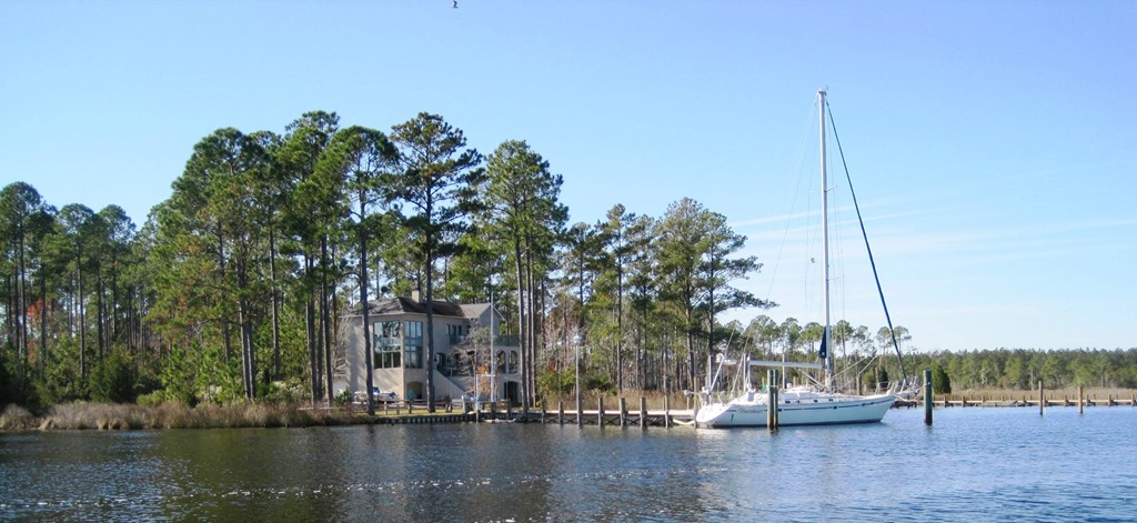
Since it was pouring buckets of rain and since we had picture of Mike and Kathy’s home we figured we could sneak into the dock before they had the chance to get out and get wet. Sadly they had engaged their neighbors further down the creek to act as spies! So arrival was met with two friends standing in rain gear waiting out arrival!

Capture -15

Here is a picture of their place with SV Braveheart who is currently “summering” in the Caribbean! 

So far its been a great trip! More from Oriental!

2015-09-14 — Galesville, MD – Hampton, VA

Magnolia and crew are away from the dock! We have been moored at our homeport ALL summer and though it was a terrific time, sailboats and sailors “need” to be on the water and away from docks. We jumped right in during our first week away from the dock, about 175 miles covered on our way to Hampton, VA.

2015_09_13_22_32_01_AWB-039

The first 25 mile leg took us to the Wye River on the Chesapeake Bay’s Eastern shore. The Wye is one of our favorite spots on the entire Chesapeake.

2015_09_13_22_05_12_AWB-040

The Admiral loves to swim in the beautiful Wye River and it was also the location for the Pentagon Sailing Club Labor Day Raft Up.

2015_09_06_09_09_44_AWB-022

Magnolia Crew in the formal attire to head for over in the dinghy Blossom for a visit to the raft. Appreciate the crew of SV Imagine allowing us to moor Blossom!

2015_09_05_20_20_16_AWB-074

Out next planned stop was planned in Solomons to visit Spring Cove Marina and to meet up with some friends we had not seen in way too long. We had a fast 50 mile sail down the bay.

2015_09_13_22_16_47_AWB-043

We had a lovely visit. This was the view from our favorite ice cream parlor right on the water.

2015_09_07_21_26_22_AWB-078

I highly recommend the Supreme with all chocolate ice cream….oh but I digress…

11990691_10207932952820557_4403025738904427597_n

Meanwhile the Navy was busy invading the Patuxent River…some kind of support craft I assume for the Patuxent Naval Air-Station located just across the river. We ended up staying in Solomons a couple extra days waiting for some weather to pass.

2015_09_10_20_32_49_AWB-034

Our patience was rewarded for our next passage the longest of the week was nearly 60 miles down to Jackson Creek at Deltaville, VA. In addition to the length we also cross the mouth of the Potomac River. The shear volume of water enter the bay from this tributary can really make for some rough water in the wrong conditions. If you need some evidence please read “2013-07-11 What we learned on our passage to Reedsville

2015_09_13_22_11_14_AWB-044

We had a terrific northwest wind blowing 15-20 all day long. Magnolia galloped down the Chesapeake Bay! It might not have been the prettiest day but our “girl” was eating it up.

2015_09_11_11_01_56_AWB-036

The “Mariner” still guards the this portion of the Chesapeake Bay

2015_09_11_11_49_31_AWB-084

As hard as I can, I am never able to capture the shear scale of the ships we pass. This is a car carrier, probably arriving Baltimore from Asia is .85 miles away from Magnolia.

2015_09_11_13_42_15_AWB-088

We anchored as usual in Jackson Creek, Deltaville, VA. Perhaps we should learn our lesson because every time we do we end up with at least one significant blow coming through! This time was not exception as the from came through Saturday as expected.

2015_09_12_18_38_35_AWB-046

2015_09_12_18_40_06_AWB-047

The passage of the front did set us for another terrific day of down wind sailing! We had a truly terrific day coming down the bay to Hampton.

2015_09_13_22_19_02_AWB-045

Wolf Trap Light…we give this one a wide berth…we suspect that name was earned!

2015_09_13_11_04_41_AWB-094

The Admiral keeping on the straight and narrow….or at least heading the right direction.

2015_09_13_13_21_36_AWB-038-1

We have a kind friend that works for Virginia Pilots. Those the guys that go out meet the arriving ships and navigates them into the port. Ed always keeps and eye out for us from his perch upon high!

2015_09_13_20_04_04_AWB-003

Though the ship traffic seemed extremely light to us even for a Sunday you can see we needed to dodge some of the big guys. Ed captured these images for us from his tracking equipment in “upon high.” Its always nice to have a “Pro” watching out for us and thankfully he has never needed to make the call, “Magnolia come right 20 degrees or you are going to run over by the ship (“fill in the blank”) Thank you again Ed!

2015_09_14_00_08_39_AWB-004

2015_09_14_00_07_55_AWB-002

2015_09_14_00_06_35_AWB-001

We are in Hampton for a Memorial Service for Annette’s Uncle who passed away recently.  We will also take care of a few chores and if things work we will be be getting my niece and husband aboard for the transit to Portsmouth! Have a good week, be safe, Magnolia and Crew!

2015-09-07 Visiting Ocracoke, NC via Boat


image

(Anthony: Chart 11550)

Roger Hammer, Pentagon Sailing Club recently was kind enough to send Magnolia an update on visiting Ocracoke, NC. He gave permission to share and hopefully some will find it useful.

“Navigation approaches — Are you planning on going down Albemarle Sound and around Richmond Island or taking the ICW Alligator River – Pungo River route to Pamlico Sound to get to Ocracoke?  I have not done the Albemarle Sound – Richmond Island route so I don’t have any first hand info getting to Ocracoke from the north.  If you do come that way, you’ll be using the Big Foot Slough Channel to get into Ocracoke.  That’s the same channel the car ferries use so it has good water all the way in.  It is narrowest at the north end and my local friends tell me that you can get a fairly strong tidal current at max flood/ebb. 

If you’re coming from the west (ICW), the Nine Foot Shoal Channel provides the most direct route into Ocracoke. Waypoints on the way out from Bay River are Brant Island Shoal to the north and Royal Shoal lights “5R”, “3” and “1” to the south.  There’s good water all around Royal Shoal Light “1” so you can cut inside and run the rhumb line from Royal Shoal “3” to Green “9” at the entrance to 9 Foot Shoal Channel.  Water depth is 8 to 9 feet across Bluff Shoal if you go inside Royal Shoal Light “1”.  It a foot or two deeper if you stay north of “1”. 

Follow the marks closely as you transit Nine Foot Shoal Channel.  It’s shallowest at the west end but we never saw less than 8 feet on our depth sounder and it gets deeper as you go in. The channel marks appeared closer together on our chart plotter than they are visually for some reason.  The marks can get a little confusing as you transit Nine Foot Shoal Channel as you can see marks in the main channel in the distance (Big Foot Slough Channel) so I watched the depth contours on my chart plotter closely to confirm I was heading for the correct marks. Note: Green Mark “5” between Red “6” and “4” was missing when we came in.  (Anthony: The missing mark is NOT yet reflected in Active Captain) I checked As you approach the main channel, be sure to honor the Red “2” and Green “1” buoy gate before turning south into Big Foot Slough Channel. The car ferries use Big Foot Slough Channel so it’s a good idea to check the ferry schedules for both the Swan Quarter and Cedar Island ferries so you don’t encounter them on the way in/out as the channel is narrow and they claim right of way (so we were told).  Once in the main channel, head south for ~1.5 miles past Red “6” and “4”.  When you get to the Silver Lake Junction Light “SL” you’ll make a sharp hairpin turn to the left to enter the Silver Lake Channel.  Plenty of water in the channel – just follow the marks. 

As you enter Silver Lake, the ferry docks will be on your immediate left, and the Silver Lake Marina Park docks just to the right of the ferry docks on the north side of the lake.  There’s also one ferry dock to the right of the park dock where one of the ferries ties up overnight.  There are plenty of guest slips both on the park docks as well as along the quay wall.  The park docks have fresh water and power but no pump out.  There are public restrooms at the building near the ferry docks but no showers.  They charge a dollar a foot at the park docks.  If you want full marina amenities, you can tie up at the Anchorage Inn and Marina which is the next set of docks down on the left.  They charge about $2 a foot.  We tied up at Anchorage Inn and Marina and they were very accommodating.  Anchorage Inn Marina has bicycles and motor scooters for rent.  You can also rent a golf cart at a number of different places in town. 

Ocracoke Town Area

The downtown area is an easy walk from the park docks and marina.  Quite a few restaurants, tourist gift shops and several art galleries.  Some of the shops are seasonal and may be closed when you are there.  If you want to go to the beach or visit the light house, recommend renting some bikes as they’re further out of town.

We had dinner at the Flying Melon one evening – on the higher end price wise but excellent food.  30-45 min wait for a table as they don’t take reservations.  Had lunch at Eduardo’s Taco Stand 1st day  – #1 rated place to eat on Trip Advisor – waited about 30 minutes for food and worth the wait.  Both of these places are on the opposite end of town – 20 to 30 minute walk.  If you need groceries or liquor, these stores are located just beyond Eduardo’s on the main road.

There’s a small local museum across the park from the ferry docks that’s worth a visit (free/donations).  The light house on the edge of town is interesting but you can’t go up inside.  There “wild” ponies/horses in a corral 7 miles out of town.  The public beach is about 2 miles out of town – very nice and clean.

The highlight of the visit was the Ocrafolk Opry on Wednesday evening hosted by the band Molasses Creek at the Deepwater Theater – eclectic mix of local/regional folk singers and story tellers.  $15 for a two hour show and they sell out every week.  Looks like their last show for the season is Wednesday, 23 September.  Not sure whether your planned visit dates will get you in there that early but it’s well worth adjusting your schedule a few days if you’re close.  “

Roger, thank you so much for allowing me to share this! More from Magnolia in a couple of days though we are currently in Solomon’s Island

2015-09-04 It’s Go Time

We have really enjoyed our extended stay here at Hartge Yacht Harbor. The yard and marina workers do good work and could not possibly been kinder or helpful. That said we have been here 3 months which is longer than we have been anywhere since we started this adventure, and its just plain time to get moving!

We do need to say thank you to everyone we spent time with this summer. We ranged from Michigan & Ohio to New Jersey, Maryland and Virginia. So many people took time out of their schedules to visit and make a few memories. We so enjoyed it, thank you!

2015_09_03_16_26_59_AWB-016

As I write this, Magnolia’s bottom paint is curing a few yards from the cottage we are staying. The guys from the paint shop are amazing in that they work hours at a time in the protective suits and always have the biggest smiles. There efforts are always appreciated.

2015_09_03_16_25_38_AWB-003

In addition the Admiral put a last minute fix into our sail cover.

2015_08_31_15_54_16_AWB-012

I got a last wash and wax done on the cabin top and gunnels.

2015_09_03_16_49_22_AWB-007  2015_09_03_17_30_48_AWB-008

The yard will put Magnolia back in the water tomorrow (Friday 4 Sept) and we will head straight out from the slings mid morning.

2015_09_02_12_04_41_AWB-014

Assuming the predicted thunderstorms hold off till late afternoon we will head straight out to the Wye River.  The Pentagon Sailing Club will be having a Labor Day Raft-Up out there and we will visit friends on Saturday. Magnolia will stay on a couple more days to allow the Admiral to get her Wye River swimming in and do a few more Magnolia system checks before we really get on our way on Tuesday.

2015_09_03_17_18_01_AWB-005

We are looking forward to the new season so if you do not come visit, please be sure to follow here. Be Safe, Be Well, A**2